
Clyde and Elam
Clyde and Elam Stoltzfus are embarking
on another exciting journey with a film
on the Kissimmee River Basin: the
Northern Everglades. We are excited to
once again be a part of educating the
people of Florida about their state, its
beautiful environment, and the wonderful
success of this restoration project.
To keep track of the progress of
the film check out:
http://www.northerneverglades.com

THE GUYS
Lawrence Glenn
Director Kissimmee Division SFWMD
Brent Anderson
Environmental Scientist/Herpetolgoist SFWMD
Clyde
William Graft
Communications SFWMD
Elam Stoltzfus
Film Maker and Producer
ABOUT THE
KISSIMMEE RIVER BASIN
Most residents of Florida think of the Everglades
as the "river of grass" located in South Florida.
However, the Everglades ecosystem begins
far north near Disney World and flows south,
170 miles, to the "river of grass" and the mangrove
islands. The headwaters of the Everglades
ecosystem impacts the entire ecosystem and is
critical to Florida's biodiversity and fresh
water resources.
Located in the center of the state, the
Kissimmee River watershed basin consists
of an upper and lower basin and is subject
of one of the largest river restorations projects
in the world. It is also one of the most
successful restorations, resulting in scientists
coming from all over the world to learn about
the techniques in successful restoration of rivers
and floodplains.
The Upper Basin is approximately 1600 square
miles in area and is comprised of numerous
lakes that historically were connect by river
and slough systems. The Lower Basin consists
of approximately 750 square miles and extends
south from Lake Kissimmee to Lake Okeechobee.
The historic river meandered approximately
103 miles within a 1-2 miles wide flood plain.

Dredging the Kissimmee Canal (C-38) in 1960
HISTORY
After several hurricanes and very wet weather
events, Congress authorized, in 1954, the
Kissimmee River Flood Control Project to
provide flood protection to the upper basin,
drain the river flood plain for agricultural
purposes and reduce flooding.
Between 1962 and 1971 the Kissimmee River
was converted from a natural system to a
channelized system (C-38 Canal) with a series of
impounded reservoirs controlled by water control
structures. Additional structures and canals were
constructed in the upper basin to allow regulation
of water flow into the now channelized system.
As a natural river, the Kissimmee supported a
mosaic of intermixed vegetation types,
productive fisheries, and large and diverse
populations of waterfowl and wading birds.
The flood control canal resulted in the loss of
approximately 19,772acres of wetlands causing
a significant loss of wetland habitat and damage
to the ecosystem functions. This caused drastic
declines in wintering waterfowl, wading birds
and game fish populations.
This highly successful engineering project was
decried for its environmental impacts even before
it was completed in 1971.
An environmental study was completed in
1971 that scientifically proved the damage the
canal/ditch was going to create. This study created
a movement to restore the Kissimmee River
back to its natural flow.
It took five years for the state to pass a
resolution to restore hydrology to the Kissimmee
River, however the resolution failed to show any
economic reason for changing the river back to
its original flow, therefore the resolution stalled
and nothing happened. In 1976-1985 a study was
undertaken to determine if there was any economic
reason to change the flow of the river to its
original condition. The study proved a good one
and the resolution moved forward.

Lawrence explaining the ecosystem
and the restoration to Elam
and Clyde
CURRENT HISTORY
PHASE ONE
The first major phase of canal backfilling began
in June 1999. During this phase approximately
7.5 miles of canal were backfilled, 1.25 miles of
new river channel were recarved, 15 continuous
miles of river were reconnected, and one water
control structure was removed. This phase of the
project is expected to reclaim approximately
11,000 acres of wetland. This phase is COMPLETE.
District scientist have already documented dramatic
evidence that the first phase is working. Continuous
flows from the upper basin have allowed water to
again flow through river channels and spill out
naturally onto the floodplain. Organic sediments are
being flushed from once-stagnant river channels, birds
and native vegetation are recovering, dissolved oxygen
levels are improving and aquatic vegetation no longer
clogs river channels.

The Kissmmee Canal is the area on
this photo that looks like a dirt runway.
To the right is the original river. When
they diverted the water into the original
river it was necessary to dredge that
area because of all the stagnant growth
clogging the original river.

In the distance you can see the old canal
In the foreground is the "real" river
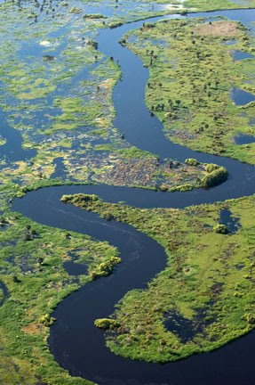
Kissimmee River meandering with
areas where the flood plain has water

The flood plain during rainy season
PHASE TWO & THREE
This phase will backfill approximately eight miles of
canal, recarve three miles of river channel, reconnect
17 miles of continuous river channel, demolish a
second water control structure and reclaim approximately
8,000 acres of wetlands.
This phase is dependent upon a number of
structural modifications and improvements,
the acquisition of needed land. These projects will
ensure flood protection for the adjacent
communities that project objectives are met.
The phase is almost COMPLETE.
OTHER RESTORATION COMPONENTS
Full restoration of the Kissimmee River and
floodplain is dependent on the Headwaters
Revitalization Project. The purpose is to change
the way water is regulated in the upper Basin to
allow for continuous flows to the restored
portions of the river. It will provide for increased
water storage capacity in lakes Kissimmee,
Hatchineha, Cypress, and Tiger and provide for
a more flexible management of lake water needs.
For more information:
South Florida Water Management District
800 - 432-2045 (tool free in Florida)
561 - 686-8800
www.sfwmd
the information contained in
these paragraphs are from the
South Florida Water Management District

The guys...

Getting the air boats ready

Brent and Clyde

Kissimmee River - restored

Into the flood plain

Discussing which way to go

Brent under the dark cloth checking
out the image in the camera


Oak Creek Marsh 2

Bill, Lawrence and Elam

A storm in the distance

Heading down an oxbow off the main river

Clyde and me sitting in the front
seat of Brent's air boat taking
in the view.

Heading out for the oak hammock
Clyde saw from a distance

In search of the oak hammock


Getting closer to the oak hammock

Niki making
my way through the grass...it was
an adventurous fun walk.

Brent & Clyde discussing photography
as they wait for the right light and
no wind.
It took awhile before Clyde was able
to capture this image. Either there
was sun with wind, or no sun with
no wind...very difficult to photograph
Spanish moss when using a slow
shutter speed and they are blowing
in the wind!

Clyde photographing marsh

Loftin Run 1

The light wouldn't cooperate for the image
that is before this one, so before
he took the above photo he swung his
camera around and took this image. The
light was overcast and it was perfect
lighting for what this image required.

Loftin Run 3
In the center of the image sitting
on a branch is an assemblage of
vultures. They are such fun creatures with
such great personalities that I was glad
Clyde finally got them in a photograph!

A late blooming Wild Pink Hibiscus

I am assuming this is a hibiscus seed
because most of the blooms were
gone on the wild hibiscus and all that
remained were these.

Making our way out of the oak
hammock

Out of the oak hammock


Clyde and Niki

Brent and Clyde

Clyde photographing Loftin Run

Loftin Run 2

Heading for home with the hopes we don't
get wet! We did get rained on, but it was just
a pleasant amount of water to cool us down.
We had a great day with great people in an
amazing environment. It is miraculous at
what nature can do to repair itself if just
given a chance!
photos by:
Niki Butcher
Elam Stoltzfus - www.liveoakproductiongroup.com
Brent Anderson - www.banature.com
1 comment:
Wonderful Journal of the Kissimmee River Basin. Please visit my "Kissimmee River" Facebook page!!
http://www.facebook.com/#!/profile.php?id=100001797850264
(The word Kissimmee is spelled wrong on your Journal page, thought I'd let you know :)
Peace...
Post a Comment